Academic Blogs
Blogged as part of individual coursework reflection at the University of Wisconsin-Eau Claire:
- Geographic Information Systems (GIS) I: http://coonenkagis1.blogspot.com/
- GIS II: http://coonenkageog337.blogspot.com/
- Geospatial Field Methods: http://coonenka.blogspot.com/
- Remote Sensing of the Environment: https://coonenkageog338.blogspot.com/
- Business Geography: http://coonenkageog352.blogspot.com/
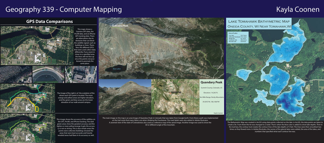
Computer Mapping Portfolio:
GRADUATE
Geospatial Coursework
Applied Geospatial Information Systems
Field Coursework
Soil Conservation and Water Management
Advanced Field and Laboratory Methods
Fluvial Geomorphology
UNDERGRADUATE
Geospatial Coursework
Geospatial Information Systems I
Field Coursework
Introduction to Geomorphology
Soils and the Environment
Fluvial Processes and Landforms
Geospatial Coursework
Applied Geospatial Information Systems
- Principles and applications of Geographic Information Systems (GIS) software.
- Examines the nature and accuracy of spatially referenced data, as well as methods of data capture, storage, retrieval, visualization and output.
- This course will emphasize the application of GIS to solving geospatial problems in various disciplines.
- Course devoted to theories and processes of analytical and automated Geographic Information Science (GIS) using python.
- Principal topics covered are spatial programming, geographic data storage, computer map rendering, application customization and automation and human interface development of GIS.
- A project-based exploration of geospatial methods and processing techniques for the analysis, modeling, and prediction of hydrologic and geomorphic processes at various landscape scales.
- An emphasis will be placed on the applications of digital elevation models, remotely sensed data, and modeling techniques to understand landscape processes of interest to fields such as geology, physical geography, agriculture, soils, ecological systems, and archaeology.
Field Coursework
Soil Conservation and Water Management
- The history and policies surrounding management of soil and water resources will be considered, but the majority of class time will be used addressing the processes of erosion and nutrient loss, and the practices used to conserve natural resources and sustain productivity/function of cropland, pasture, urban, and wild landscapes.
Advanced Field and Laboratory Methods
- Advanced training in laboratory and field methods in geography and geology.
- Topics include watershed monitoring techniques, geochemical techniques, and field studies in remote areas.
Fluvial Geomorphology
- Study of the formation, composition, distribution of fluvial landforms.
- Emphasis is on channel hydrology, quantification of geomorphic relationships, reach and watershed-scale processes, sediment transport, water and sediment contamination, and management applications to streams in the Ozarks Region as well as other places.
UNDERGRADUATE
Geospatial Coursework
Geospatial Information Systems I
- Introduction to the fundamental concepts of GIS technology and the utilization of spatial data for solving geographic problems.
- Raster and vector approaches to spatial processing are examined and special emphasis was given to raster based systems.
- Project-based hands-on learning for field data collection techniques/methods.
- Traditional and advanced geospatial technology are implemented in the course through use of ArcGIS Online, ArcGIS Pro, ArcMap, ArcScene, ArcCollector, Survey 123, and surveying methods in the field.
- Focus is on gaining additional technical skills and applying them to answer more in-depth geospatial questions including the use of network analysis, raster modeling, geocoding, PLSS, introduction to python scripting.
- Descriptive interpretation of remote-sensing images from ground, aerial, and space platforms.
- Introducing techniques such as Radiometric Enhancement, Image Mosaicking, Binary Change Detection, LiDAR from Point Cloud, Geometric Correction using GCPs, Photogrammetry, Spectral Signature analysis and resource monitoring
- Introduction to the uses of computers in the design and construction of maps using ArcGIS and Adobe Illustrator
- Topics include digitizing tasks, the organization and utilization of mapping software, and the production of computer-drawn maps including: 3D Images, Bathymetric Maps.
- An introduction to spatial/quantitative methods in geography.
- Topics include central tendency, mean center, probability, regression, spatial autocorrelation, and geographically weighted regression.
Field Coursework
Introduction to Geomorphology
- An introduction to physical processes that affect the Earth's surface and the landforms that result
- The techniques of investigating landforms (field/laboratory) and the fundamentals of communicating the results
Soils and the Environment
- Studied soil properties, formation processes, and classification with emphasis on fieldwork, application of soil information to resource management and land use, and technical report writing.
- Class project investigated the study area, about ten acres located within the exurban fringe of the city Eau Claire, WI near the town of Bracket, in West Central, WI.
- The study area is characterized by a steep north facing bedrock-controlled slope where sandstone bedrock is overlain by terminal late-Pleistocene loess.
- The class then provided land use recommendations based on observed soil characteristics.
Fluvial Processes and Landforms
- Studied river processes and the landforms that result from them, including how processes and landforms respond to natural and anthropogenic environmental change.
- Investigations of streams in the Eau Claire, WI area emphasized.
