"Geomorphic Investigations of Newly Identified Linear Dunes in Western Wisconsin"

Abstract
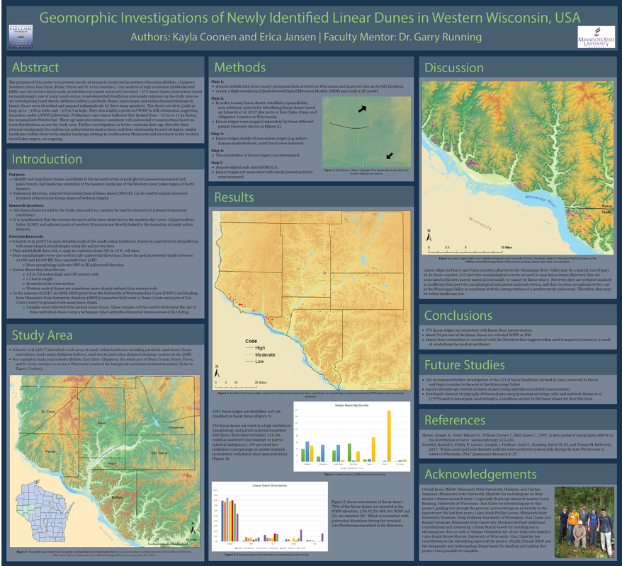
The purpose of this poster is to present results of research conducted in western Wisconsin (Buffalo, Chippewa, Southern Dunn, Eau Claire, Pepin, Pierce and St. Croix Counties). Our analysis of high resolution LiDAR-derived DEMs and soil texture data (sandy, gravel-free soil parent materials) revealed ~231 linear dunes (interpreted based on morphology), one of many sandy eolian (wind-deposited) landforms previously unknown in the study area we are investigating (sand sheets, deflation hollows, parabolic dunes, sand ramps, and eolian dammed drainages). Linear dunes were identified and mapped independently by three team members. The dunes are 84 to 8,050 m long, up to ~100 m wide, and ~1.5 to 3 m high. They also exhibit a preferred WNW to ESE orientation suggesting formation under a WNW paleowind. Preliminary age control indicates they formed from ~13 ka to 11 ka during the terminal late-Pleistocene. Their age and orientation is consistent with paleowind reconstructions based on loess distributions across the study area. Further investigations to better constrain their age, describe their internal stratigraphy (to confirm our paleowind reconstruction), and their relationship to sand stringers, similar landforms widely observed in similar landscape settings in southeastern Minnesota and elsewhere in the western Great Lakes region, are ongoing. |
|
"Ecuador: Culture and Geography"
Abstract
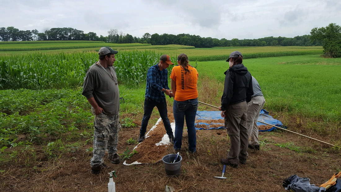
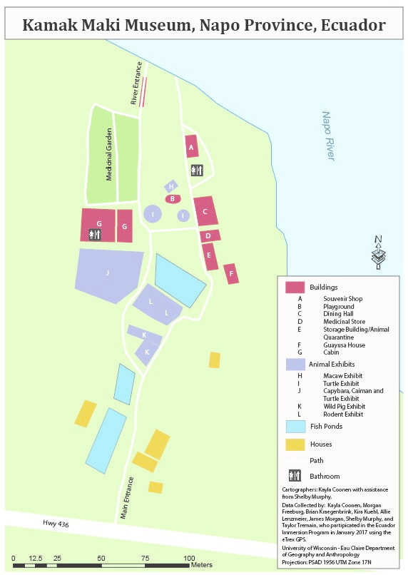
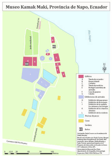
During the Winterim of 2017, I participated along with 15 other students on a faculty-led study abroad program to Ecuador. During the program, we conducted two service learning projects and a reflective analysis portayed in a story map. The first one involved digging a trench to place an underground water pipe for the museum. The new system will allow for the water source that flows through the site. The second project was creating a tourism map for Museo Kamak Maki. Using the eTrex GPS, a group of students from the University worked to collected data points that would form the pathways and building points. In ArcMap, all the polygons were created for the buildings as well as adjusted the paths. From there, Illustrator was used to create the legend and label the attractions of the Museum. I was fortunate enough to collaborate with the owners of Kamak Maki to produce/translate the maps into English, Spanish and Kichwa. For tourism purposes, English was selected for the foreign tourists, Spanish for the local tourists, and Kichwa for the locals and cultural preservation. While in Ecuador, I experienced first-hand the impacts of globalization on the numerous indigenous people we visited. A story map was created to discuss the theory behind globalization and then illustrate its various impacts on society in Ecuador—particularly indigenous communities. |
|
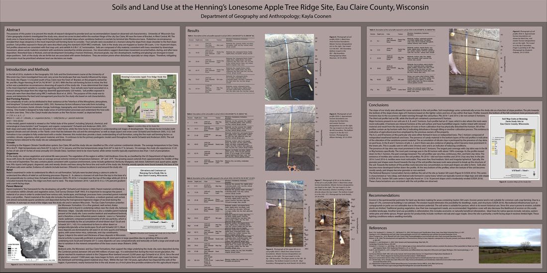
“Soil and Land Use of the Henning’s Lonesome Apple Tree Ridge Site, Eau Claire County, Wisconsin”

Abstract
The purpose of this poster is to present the results of research designed to provide land use recommendations based on observed soil characteristics. University of Wisconsin-Eau Claire geography students investigated the study area, about ten acres located within the exurban fringe of the city Eau Claire, WI near the town of Bracket, in West Central, WI. The study area is characterized by a steep north facing bedrock controlled slope where sandstone bedrock is overlain by terminal late-Pleistocene loess. Pedestrian reconnaissance revealed that slope steepness is the most important soil forming factor to consider. Four soil pits were excavated on a transect along the slope from slope shoulder to the foot slope position. Soil profiles exposed in those pits were described using the standard USDA NRCS methods. Soils in the study area are mapped as Seaton Silt Loam, 12 to 18 percent slopes. Soil profiles observed are consistent with that map unit, and exhibit A-E-Bt-C-2C horizonation. Soils are composed of silty material, consistent with loess reworked by downslopemovement, above sandy material consistent with sandstone reworked by similar processes. Our observations suggest downslope movement occurred before, during, and after loessdeposition. Reworked loess is thickest, and soil development (including e-horizon thickness, structural grade, clay skin development, mottling and gleying) are strongest in lowerslope positions. Soils at the study site are fertile but are associated with severe limitations. They are erosion prone when disturbed, especially on steep slopes. Therefore, mitigatingsoil erosion must be prioritized whatever land use decisions are made. |

|
Appendix:
Below are the PDF's to each of the posters above for a better and larger view:
|
| ||||||||||
Below are the PDF's to each of tourism maps that were translated into the 3 different languages for Museo Kamak Maki. For more information about this museum visit: http://www.museokamakmaki.com/.
| kamakmaki_tourismmap_english.pdf |
| kamakmaki_tourismmap_kichwa.pdf |
| kamakmaki_tourismmap_spanish.pdf |
