Stream Bank and Bar Erosion Contributions and Land Use Influence on Suspended Sediment Loads in Two Ozark Watersheds, Southeast Missouri
|
Abstract
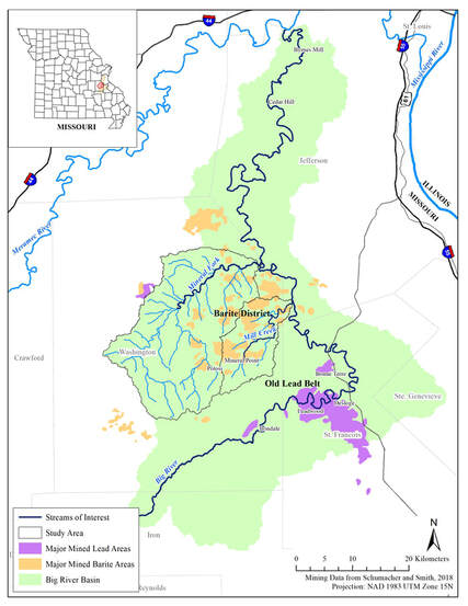
In-channel sources and storages of fine-sediment such as in banks and bars can influence sediment loads and overall geomorphic activity in stream systems. However, in-channel processes and effects on sediment load are rarely quantified in geomorphic or water quality studies. This study uses a sediment budget approach to assess the influence of bank erosion and bar deposition on fine sediment loads in Mineral Fork (491 km2) and Mill Creek (133 km2) watersheds located in the Ozark Highlands in Washington County, Missouri. These watersheds were disturbed by historical lead and barite mining which included the construction of large tailings dams across headwater valleys. USEPA’s Spreadsheet Tool for Estimating Pollutant Loads (STEPL) was used to quantify suspended sediment delivery from upland areas and assess land use-load relationships. Aerial photographs from 1995 and 2015 were used to identify spatial patterns of erosion and deposition in bank and bar forms. LiDAR was used to characterize the channel network and determine bank and bar heights. Field measurements were used to ground-truth bank and bar heights and fine-sediment composition of alluvial deposits. Historical tailings dams capture runoff from 27% of Mineral Fork and 28% of Mill Creek drainage areas, trapping 38% and 26% of the suspended sediment load annually, respectively. The total annual sediment yield for Mineral Fork watershed was 92 Mg/km2/yr with 55% released by bank erosion and <1% reduced by bar storage. The sediment yield for Mill Creek was 99 Mg/km2/yr with 33% released by bank erosion and 24% reduced by bar storage. These results indicate that in-channel processes are important contributors to sediment yields in these watersheds. |
|
Nonpoint pollution source modeling and bank erosion contribution in Mineral Fork and Mill Creek watersheds, SE Missouri
- Poster Presented at Missouri Natural Resources Conference at Tan-Tar-A Resort in Osage Beach, Missouri, February 2020.
|
Abstract
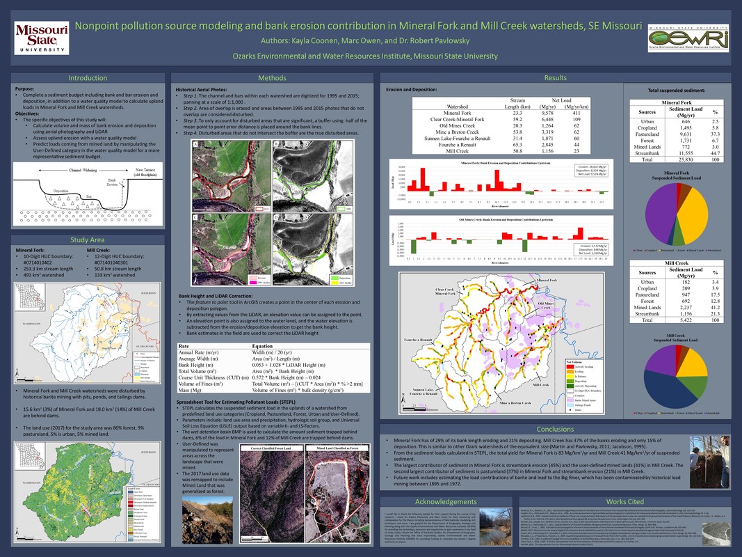
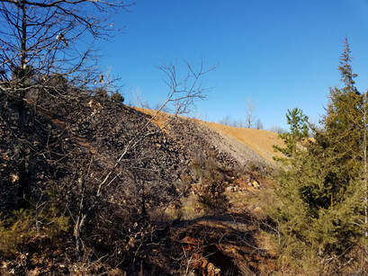
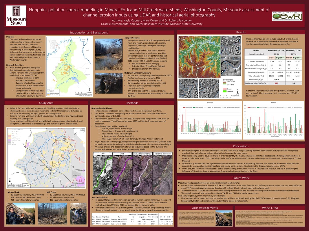
Nonpoint source (NPS) pollution is the leading source of water-quality impacts to surface water in the United Sates. This study aims to develop a NPS model for sediment and nutrients using USEPA’s Spreadsheet Tool for Estimating Pollutant Loads (STEPL) for Mineral Fork (491 km2) and Mill Creek (133 km2) watersheds in Washington County, Missouri. These watersheds offer a challenge because the drainage network was disturbed by historical barite mining with pits, ponds, and tailings dams. This research reports on the methods and spatial analysis of bank erosion rates to provide input data to support NPS modeling. Historical aerial photographs from 1995 to 2015 are compared to identify bank erosion and deposition trends over 20 years by digitizing the active channel. LiDAR is used to develop cross-sections along disturbed areas to determine bank height. In order to reduce suspended sediment loads, it is important to identify the land use and land cover contributions such as anthropogenic activities that could impact pollution influences like bank erosion. Sediment budgets determine the sediment input and storage to estimate fluxes of sediment. About 163.8 km2 of Mineral Fork and Mill Creek’s drainage area is trapped behind tailings dams, reducing the sediment load by 16% in Mineral Fork and 28% in Mill Creek. With an average bulk density of 1.34 Mg/m3, the estimated sediment yield produced is 23 Mg/km2/yr in Mineral Fork and 39 Mg/km2/yr in Mill Creek. Of that sediment yield, 30% is from streambank erosion in Mineral Fork and 54% in Mill Creek. |
|
Bank erosion assessment using historical aerial photography and LiDAR in a Missouri Ozarks watershed
- Poster presented at the Association of American Geographers Annual Meeting in Washington, D.C. on April, 2019
|
Abstract
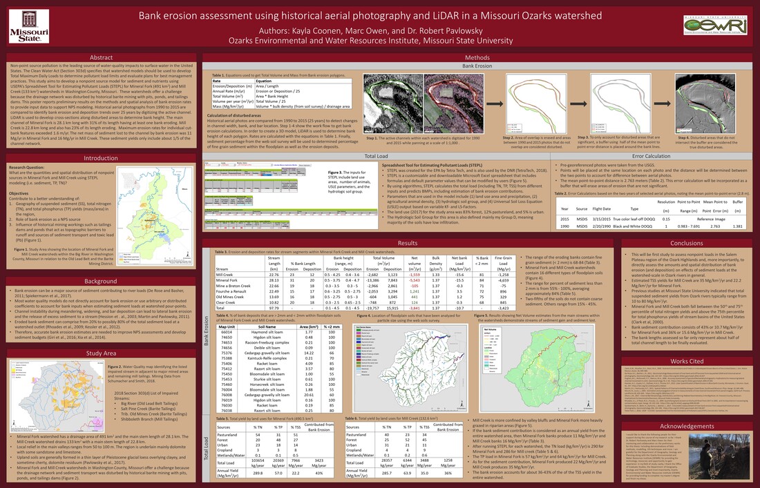
Non-point source pollution is the leading source of water-quality impacts to surface water in the United States. The Clean Water Act (Section 303d) specifies that watershed models should be used to develop Total Maximum Daily Loads to determine pollutant load limits and evaluate plans for best management practices. This study aims to develop a nonpoint source model for sediment and nutrients using USEPA’s Spreadsheet Tool for Estimating Pollutant Loads (STEPL) for Mineral Fork (491 km2) and Mill Creek (133 km2) watersheds in Washington County, Missouri. These watersheds offer a challenge because the drainage network was disturbed by historical barite mining with pits, ponds, and tailings dams. This poster reports preliminary results on the methods and spatial analysis of bank erosion rates to provide input data to support NPS modeling. Historical aerial photographs from 1990 to 2015 are compared to identify bank erosion and deposition trends over 25 years by digitizing the active channel. LiDAR is used to develop cross-sections along disturbed areas to determine bank height. The main channel of Mineral Fork is 28.1 km long with 31% of its length having at least one bank eroding. Mill Creek is 22.8 km long and also has 23% of its length eroding. Maximum erosion rates for individual cut-bank features exceeded 1.6 m/yr. The net mass of sediment lost to the channel by bank erosion was 11 Mg/yr in Mineral Fork and 16 Mg/yr in Mill Creek. These sediment yields only include about 1/5 of the channel network |
|
Nonpoint pollution modeling in Mineral Fork and Mill Creek watersheds, Washington County, Missouri: assessment of channel erosion inputs using LiDAR and historical aerial photography
- Poster Presented at Missouri Natural Resources Conference at Tan-Tar-A Resort in Osage Beach, Missouri, February 2019.
- Poster Presented at Upper Midwest Stream Restoration Symposium at the Radisson Hotel in La Crosse, Wisconsin, February 2019.
|
Abstract
Non-point source (NPS) pollution is the leading source of water-quality impacts to surface water in the United Sates. The Clean Water Act (Section 303d) specifies that watershed models should be used to develop Total Maximum Daily Loads (TMDLs) to determine pollutant load limits and evaluate plans and effectiveness for best management practices. This study aims to develop a nonpoint source model for sediment and nutrients using STEP-L for Mineral Fork and Mill Creek watersheds in Washington County, Missouri. These watersheds offer a challenge in that the drainage network and sediment transport has been disturbed by large-scale barite mining with pits, ponds, and tailings dams. In addition, modeled sediment loads will be used to estimate the lead loads into Big River to evaluate the relative contributions of mining-related lead from St. Francois and Washington counties. This poster reports preliminary results on the sampling and spatial analysis of bank erosion rates in the watersheds to provide input data to support NPS modeling. Historical aerial photography and LiDAR are used to estimate bank erosion inputs for different locations along the channel network. Ultimately, this study will contribute to a better understanding of nonpoint sources in southeastern Missouri and aid in evaluating the influence of historical mining in Washington County on lead contamination in Big River. |
|